36 mineral claims and 2,016 hectares
The Lac Brule hemo–ilmenite deposit is:
The Company will be taking steps to advance the Lac Brule project through Preliminary Economic Analysis (PEA) stage to provide the Company a degree in optionality with its development pipeline.
Much of the work outlined below will be driven by future money raises but are included herein as part of a road map for where Temas intends to take this work.
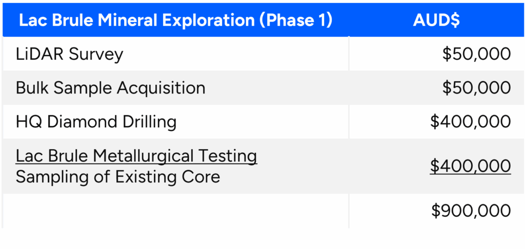
Key components of the Lac Brule Field program include:
1. Fly a detailed LiDAR survey to establish pre-disturbance topographical controls, define structural components and help constrain more precise volumes within the outcropping and sub cropping hem ilmenite mineralization like Rio Tinto’s Lac Tio mine.
2. Obtain a bulk sample from surface showings to conduct metallurgical testing through existing facilities operated by potential partners to allow us to evaluate the value in use for this high grade (>34% TiO2) material.
3. Complete HQ definition drilling designed to confirm and expand historic drill results and obtain samples for metallurgical testing at the bench and pilot scale to design an initial flowsheet design. All drilling objectives outlined for La Blache will be followed at Lac Brule.
4. Complete an initial resource calculation and PEA.
Lac Brule is comprised of 36 claims, covering 2,016 hectares within the Labrieville Anorthsosite Complex
64km by road accessible from Labrieville (30km in a straight line), on the north shore of the St. Lawrence 100km north of Forestville, near the Bersimis 2 power generation site.
Favorable mineralization for the application ORF TiO2 technology proved to be 144.8% more cost-efficient than conventional processes.
Historic drilling conducted across 2 mineralized lenses
Historic metallurgical bench tests attained 94% TiO2, 95% V2O5 and 99% iron oxides successfully leached
The mineralization is hosted in at least two massive hematite-ilmenite tabular lenses within the Labrieville anorthosite layered complex. The lenses trend NW and dip 25° ENE. These lenses outcrop in a cliff along Lac Lise road and are intercepted at surface and at a depth of 30 metres below surface in the drilling conducted to date. A VTEM survey conducted by the previous land holder delineated a 2.5km conductor. Additional conductors identified on the property have only seen initial exploration with limited surface sampling. One of these conductors, located northwest of the mineralized lenses yielded results which included a grab sample assaying 35.5% TiO2.
| Hole Id | From (m) | To (m) | Interval (m)* | Fe2O3 % | TiO2% | Ti % | V2O5% | V% | Lens Id |
|---|---|---|---|---|---|---|---|---|---|
| LB-18-23 | 4.50 | 11.40 | 6.90 | 58.13 | 35.56 | 21.32 | 0.373 | 0.209 | Lens 1 |
| LB-18-24 | 2.00 | 18.93 | 16.93 | 54.73 | 33.52 | 20.10 | 0.345 | 0.194 | Lens 1 |
| LB-18-25 | 12.95 | 25.65 | 12.70 | 57.84 | 35.41 | 21.23 | 0.370 | 0.207 | Lens 1 |
| LB-18-26 | 28.78 | 49.52 | 20.74 | 58.59 | 35.02 | 20.99 | 0.207 | Lens 1 | |
| LB-18-27 | 3.30 | 6.76 | 3.46 | 25.37 | 14.77 | 8.85 | 0.154 | 0.086 | Lens 2 |
| LB-18-27 | 25.88 | 43.10 | 17.22 | 58.05 | 34.71 | 20.81 | 0.366 | 0.205 | Lens 1 |
| LB-18-28 | 5.50 | 15.25 | 9.75 | 57.16 | 34.05 | 20.41 | 0.359 | 0.201 | Lens 2 |
| LB-18-28 | 18.46 | 36.81 | 18.35 | 58.31 | 35.07 | 21.03 | 0.368 | 0.206 | Lens 1 |
| LB-18-30 | 12.65 | 29.00 | 16.35 | 58.08 | 35.49 | 21.28 | 0.368 | 0.206 | Lens 1 |
| LB-18-31 | 20.77 | 43.20 | 22.43 | 56.97 | 34.03 | 20.40 | 0.361 | 0.202 | Lens 1 |
| LB-18-32 | 3.00 | 13.50 | 10.50 | 51.00 | 30.97 | 18.57 | 0.317 | 0.177 | Lens 2 |
| LB-18-32 | 30.90 | 59.12 | 28.22 | 58.16 | 35.80 | 21.47 | 0.370 | 0.207 | Lens 1 |
| LB-18-33 | 34.00 | 50.30 | 16.30 | 58.27 | 35.23 | 21.12 | 0.373 | 0.209 | Lens 1 |